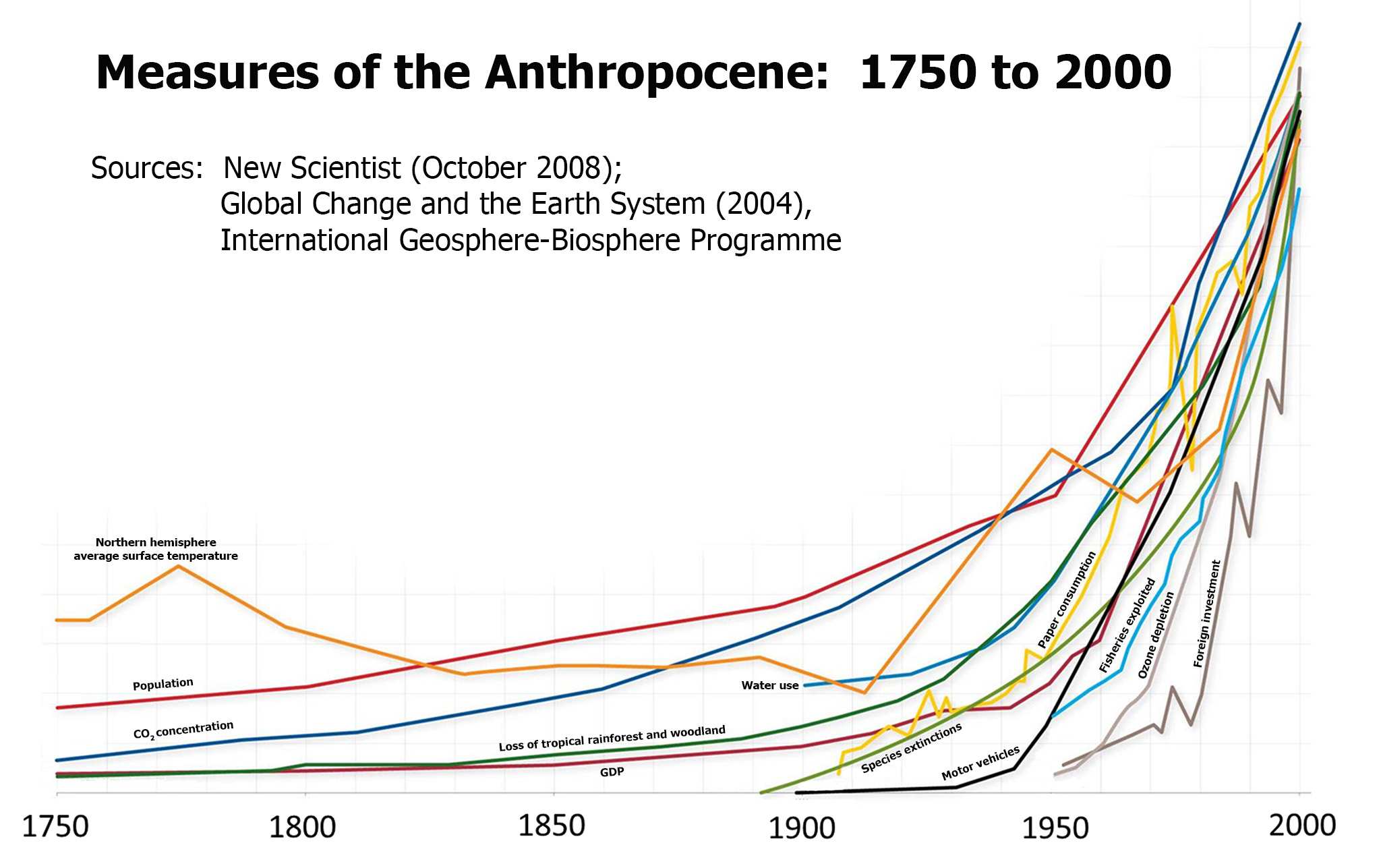
The Anthropocene is what scientists are starting to call our current geological era. Those in favor of this new idea are proposing that the Holocene, which is what is currently accepted as our current geological era, is over. There is good reason to go along with this new concept. The Holocene describes an earth controlled by glaciers. This is not really the case anymore since most of the glaciers have melted and humans have begun to take a major role in the Earth’s geological systems.
The change cannot happen right away. Scientists will need to come together and decide on this new change to an old system. It will be interesting in the future to find out the outcome of the Anthropocene.
Works Cited
Van der Plujim, B. (2016). Here Comes the Anthropocene - Eos. Retrieved September 26, 2016, from https://eos.org/editors-vox/here-comes-the-anthropocene
Showstack, R. (2016), Scientific study group favors recognizing human-influenced epoch, Eos, 97,doi:10.1029/2016EO058567. Published on 01 September 2016.
Welcome to the hot spot, your weekly source for exciting, interesting, and wild GEOLOGY-themed stories that we will dig up, as a class, this semester! Remember, your blog entries should be no more than ONE page long, must include at least one image that helps illustrate the story you are telling, and should be relatively jargon-free. The topic is wide open, as long as there is a connection to geology AND the story is relatively current.
Monday, September 26, 2016
Sunday, September 25, 2016
Run Penguins, Run!: Volcanic Eruption Endangering the Largest Colony of Chinstrap Penguins on Earth
Chinstrap Penguin covered
in Volcanic Ash
|
On the small
island of Zavodovski in the Sub Antarctic, two volcanoes, Mt. Curry and Mt.
Sourabaya, have been erupting since March 2016, depositing volcanic ash over up
to half of the island. Now you may be thinking: “Who cares if some volcano
erupts in the Sub Antarctic? I mean seriously that’s the middle of nowhere.”
Well, my friend, let me introduce you to the adorable species called Pygoscelis
antarcticus, more commonly known as the Chinstrap Penguin.
Zavodovski
Island is home to over 1 million Chinstrap Penguins—the largest colony for this
penguin species in the world—as well as about 180,000 Eudyptes chrysolophuses,
or Macaroni Penguins. Although the primary eruption is on the
Western side of the island, wind has been blowing smoke and ash to the East,
depositing it to the lower slopes of the volcano where the Chinstrap and
Macaroni Penguins call home.
Unfortunately,
there was no escape for these penguins, since they were moulting (shedding
their feathers) at the time of the eruption, and were thus unable to leave the
island. Many are left covered in volcanic ash, made of steaming hot chunks of
rocks, minerals, and volcanic glass. That is not stuff you want up in your
feathers.
But how exactly
did these evil volcanoes endanger the cute little penguins? How did this
eruption occur? I am here to tell you.
| Plate interactions surrounding the sandwich plate |
Zavodovski
island is part of a chain of islands on the South Sandwich Plate (yes, that is
its official name). The South Sandwich Plate is an oceanic microplate (a
relatively teensy portion of Earth’s crust/surface) in the South Atlantic Ocean
located East of the tip of South America. It is termed the “Sandwich” Plate because
it is sandwiched between two different types of plate boundaries—to the West,
the Sandwich Plate helps form the East Scotia Ridge as it spreads away from the
Scotia Plate, while to the East, it helps form the South Sandwich Trench as the
much larger South American Plate is subducted underneath it.
But what
does this have to do with the poor penguins? Everything.
| Volcanic island arc formation |
As the South
American Plate goes underneath the Sandwich Plate, water is squeezed from the
South American Plate, causing melting of the mantle (the layer of the Earth
between the outer crust and inner core) above. This leads to the growth of
volcanoes from the ocean floor in the form of a volcanic island arc, which has now
grown so large that it is visible as the island chain that the Chinstrap and
Macaroni Penguins inhabit today. These volcanoes are active and highly
explosive, and can cause eruptions like the one that began in March.
Due to the
remote location of the island, scientists cannot yet confirm the impact of the
eruption. It is possible that the penguins could be mostly unaffected. My
fingers are crossed for our feathery friends.
Sources:
Brett, C. P. “Seismicity of the South Islands Sandwich Region.” Geophysics Journal International, vol.
207, no. 2, 2016, pp. 453-464.
British Antarctic Survey. "Penguin
colonies at risk from erupting volcano." ScienceDaily. ScienceDaily, 6
July 2016.
Osborne, Hannah.
"Erupting Volcanos Are Threatening One of the World's Largest Penguin
Colonies." Ibtimes.co.uk. International Business Times, 06 July
2016. Web. 25 Sept. 2016.
Tarling,
Matthew. "South Sandwich Plate." Antarctic-plate-tectonics.weebly.com.
N.p., n.d. Web. 25 Sept. 2016.
Photos:
http://www.telegraph.co.uk/content/dam/science/2016/07/06/penguin1-xlarge_trans++lICCrqpqBXeeiDzFnh4JCBTEH5qRvDzx2sYmxcyot7w.jpg
http://antarctic-plate-tectonics.weebly.com/uploads/2/5/8/0/25809939/9947681.png?681
http://study.com/cimages/videopreview/c4kgits79v.jpg
Drilling companies' dreams not yet fractured by proof of induced seismic activity
A recent study claims that the largest earthquake on record in eastern Texas was triggered by wastewater injections associated with the oil-drilling technique known as hydraulic fracturing, or "fracking."
Sources
Fracking is the process by which natural gas, oil, and their surrounding water is extracted from the Earth, while wastewater injection involves drilling wells—to a depth of up to a mile—in order to dispose of that water, deemed useless by drilling companies. Geologists and geophysicists have long suspected that fracking and its related processes can induce seismic activity in areas where earthquakes would be uncommon. The locations of major quakes in Texas were easily correlated with wastewater disposal well sites, but scientists now have definitive proof that these temblors did not have a natural origin.
![]() |
| The largest earthquake on record in eastern Texas was a magnitude 4.8 in 2012. |
The study utilized a remote sensing practice called Interferometric Synthetic Aperture Radar (InSAR), which uses satellite radar to detect miniscule changes to Earth's surface on the order of centimeters. The team of scientists focused on tracking nearby surface uplift in conjunction with disposal well location and depth. It was found that while the shallower wells caused some minor uplift up to miles away from the drill site, they were not deep enough for the volume of water injected to cause any significant increase in underground pressure. The two wells located the closest to the 2012 quake were much deeper, having drilled beneath a layer of impermeable rock to the "crystalline basement," where earthquakes often originate along underground fault lines. Although the volume of water injected at these wells was approximately the same as the shallower ones, the effect of the pressure increase close to these faults reduced the friction holding the faults in place and caused them to slip, triggering earthquakes that could easily be sensed at the surface.
Will studies like these be enough to stop the practices of hydraulic fracturing and fluid injection in Texas? Well, for one thing, definitely not; and for another, scientists are of the opinion that even if fracking is to continue, this dangerous seismic activity can at least be avoided by choosing more strategic drilling sites and injection volumes. William Ellsworth, a Stanford geophysicist associated with the project, suggests locating shallow wells above "blocking formations"—the same kind of impermeable rock layers that trapped the rising underground pressure along fault lines near the deep wells. By making wastewater injections just above this layer as opposed to just below, the pressure will spread out instead of concentrating in a single area; so while surface uplift may be inevitable on a small scale, it is at least possible to prevent a repeat of the 2012 quake.
Sources
Diep, F. (2016, September 22). Did fracking wastewater disposal cause East Texas' biggest earthquake? Pacific Standard. Retrieved from https://psmag.com/did-fracking-wastewater-disposal-cause-east-texas-biggest-earthquake-d9766b1c386d
Shirzaei, M., Ellsworth, W. L., Tiampo, K. F., Gonzalez, P. J., & Manga, M. (2016). Surface uplift and and time-dependent seismic hazard due to fluid injection in eastern Texas. Science, 353(6306). Retrieved from http://science.sciencemag.org/content/353/6306/1416.full
Than, K. (2016, September 22). Satellites help link Texas earthquakes to wastewater injection, Stanford scientist says. Stanford News. Retrieved from http://news.stanford.edu/2016/09/22/satellites-link-texas-earthquakes-wastewater-injection/
Saturday, September 24, 2016
Trees apparently in no hurry to help us out with global
warming:
A study of earth dynamics shows that trees take thousands of
years to store carbon in the ground
It’s common knowledge that trees
absorb Carbon dioxide and pump out oxygen, and this has a big impact on
conversations and actions aimed at reducing global warming. Environmental groups lobby against
deforestation, trees get planted in cities, and companies and institutions
(such as Macalester) offset their carbon footprint by hiring companies to plant
trees for them. However, a recent study
done by environmental scientists at UC Irvine found that soil absorbs and
stores carbon much more slowly than previously thought.
Trees absorb carbon dioxide from
the air through photosynthesis, and when they die and decompose they become
part of the soil, which locks carbon on and in the ground, keeping it out of
the atmosphere. It’s the “locking” part
that scientists have discovered takes much longer than anyone thought. The scientists combined radiocarbon dating
tools with other simpler ways of analyzing soil and studied 157 samples from
around the world. They found that the
carbon in the soil was older than they thought by over a thousand years. The previous estimate for how long it takes
carbon absorbed by trees to integrate the earth was 450 years. The scientists from UC Irvine found carbon of
this type over 3000 years old in their samples.
Although this could seem like a
blink of an eye when thinking in geologic time and the comparing it to the
processes that shape the earth, compared to our ability to pollute as a species
this is a big chunk of time. If scientists estimate that the Earth will be
8⁰ C warmer by 2300, then while people are enjoying tropical vacations in
Alaska (and a few islands have disappeared) the ground under the unusually old
oak tree in the park down the street from your house might still be working on swallowing
the carbon that came out of your mom’s CRV (now a highly valued collector
vehicle) as she drove you to little league.
Polluting is more costly than ever given the pace that the
earth seems capable of integrating it (Yujie)
The punch line of this article is that now that we know that
the ground absorbs carbon fairly slowly we need to be more proactive about
reducing our carbon emissions if we want to reduce global warming and prevent
the bad global changes that it would bring about.
Yujie He
et al. Radiocarbon constraints
imply reduced carbon uptake by soils during the 21st century. Science,
September 2016 DOI:
"Soil Will Absorb Less Atmospheric Carbon than Expected
This Century, Study Finds." ScienceDaily. ScienceDaily, n.d.
Web. 24 Sept. 2016.
Monday, September 19, 2016
Massive Sinkhole Contaminates Floridian Aquifer!!!
In Mulberry, Florida, the New Wales plant, where phosphate rock is mined and converted into fertilizer was dumped into a major Floridian aquifer because of the collapse of a sinkhole. Now what is a sinkhole? And what is an aquifer?
A sinkhole is formed when usually water-soluble rock crashes into an open cavity below it because it can no longer handle the pressure from above. In this case the water-soluble rock is known as gypsum. The groundwater eroded the gypsum bedrock and formed a large void over the period of hundreds of millions of years!
An aquifer is space underneath the ground that holds fresh water. These reservoirs are usually guarded from evaporation loss or pollution because of their location in the grounds.
Now that we know what these super scientific terms means, let’s put that into perspective. Imagine your main source of water… the water you use to bathe, to drink from, to clean your dogs. Now imagine doing all those activities with contaminated water… gross huh? The water from the plant was “spiked” with sulfate, sodium. Because of the gypsum stack that collapsed, there are also traces of gypsum in the aquifer. Gypsum is a byproduct of fertilizer and contains low levels of radiation. The acidity of the contaminated water is close to the acidity of vinegar or lemon juice.
Not only is the contamination a problem, but the size and amount of water polluted is awful. This sinkhole was huge! At around 45 feet wide, the plant on top might have dumped up to about 215 million gallons for at least three weeks.
The problem is, this is not a quick fix… it could takes months to plug the hole and nearly impossible to sanitize the aquifer. There are steps taken to resolve this problem. The plant company, Mosaic is using a well that pumps 3,500 gallons of water per minute back into the aquifer. It will then fill the sinkhole with concrete-like ground.
Sinkholes are very unpredictable and usually induced by human-activity, and just like this case, could cause tremendous problems.
Watch the video: http://interactive.tegna-media.com/video/embed/embed.html?id=2363300&type=video&title=Mosaic%20plant%20sinkhole&site=67&playerid=6918249996581&dfpid=32805352
Sources:
AccessScience Editors. (2014). The causes of sinkholes. In AccessScience. McGraw-Hill
Christopher O'Donnell, Times Staff WriterLinkView All Articles. "Mosaic Plant Sinkhole Dumps
215 Million Gallons of Reprocessed Water into Floridan Aquifer (w/video)." Tampa Bay
Times. N.p., n.d. Web. 19 Sept. 2016.
Linsley, Ray K. (2014). Aquifer. In AccessScience. McGraw-Hill Education. http://dx.doi.org/
10.1036/1097-8542.045600
Sunday, September 18, 2016
Record for oldest fossils already set in stone? Think again, say scientists
New fossil records were recently
discovered in the Isua Greenstone Belt region of Greenland. Well, “new” might not be quite the right word
– these fossils are actually thought to be from around 3.7 billion years
ago.
Up until recently, it was widely
accepted that the oldest life on Earth existed 3.48 billion years ago. Evidence for life at this date can be
witnessed today in fossil records preserved in Shark Bay, Australia. I hate to break it to you, Shark Bay, but you
just got one-upped. These recent
findings in southwest Greenland push back the date of earliest known life on Earth
by about 220 million years. To give you
an idea of that time scale, imagine jumping back in time 200 million years from
today – you would find yourself among the dinosaurs.
The Isua Greenstone Belt is made up
of some of the oldest sedimentary rocks in the world, and it was here that the
“world’s oldest fossils” were found.
These 3.7-billion-year-old rocks contain ancient stromatolites, which are
wavy-looking structures built by communities of microbes (teeny tiny
creatures). Over time, these microbes
glued sediments together with carbonate, leaving behind fossilized layers of
limestone. Stromatolites may not look as
exciting as the Tyrannosaurus Rex skull that pops into your head when you hear
the word “fossil,” but they provide evidence of ancient bacterial colonies that
lived in shallow marine environments, adding to our understanding of how life
developed on Earth.
![]() |
| Fossilized stromatolites. |
Located near the Arctic ice cap, these
fossilized stromatolites came to light only recently because they used to be
covered by snow and permafrost. Rising
global temperatures have caused glaciers and sea ice to melt at increasing
rates. The rocks containing the ancient microbial
remnants were revealed after the ice covering them melted. Even though the freshly exposed rocks give us
a unique opportunity to gain insight into ancient life, global warming is a
serious issue. If humans continue
burning all of the planet’s fossil fuels, it is estimated that the Earth will
be 8⁰
C warmer by 2300. Under these
conditions, you could go on a tropical paradise vacation in Alaska – but numerous
species would also go extinct.
This new evidence of ancient life is being contested and debated. Over the scale of geologic time, rocks are cooked and compressed, many becoming so deformed that it can be hard to trace their history. The claim that these stromatolites are remnants of the oldest life on Earth will have to withstand a lot more examination, analysis, and discussion before they become widely accepted.
Nutman, A. P., Bennett, V. C., Friend, C. R., Kranendonk, M.
J., & Chivas, A. R. (2016, August 31). Rapid emergence of life shown by
discovery of 3,700-million-year-old microbial structures. Nature.
doi:10.1038/nature19355
Howard, B. C. (2016). World’s Oldest Fossils Discovered Due
to Climate Change. National Geographic.
Retrieved from http://news.nationalgeographic.com/2016/09/worlds-oldest-fossils-stromatolites-discovered-climate-change/
Pease, R. (2016). Wavy Greenland rock features ‘are oldest
fossils.’ BBC News. Retrieved from http://www.bbc.com/news/science-environment-37235447
Subscribe to:
Posts (Atom)