Sunday, October 16, 2016


Listen up Dude– Predicting Volcanoes 1.0                
Figure 1  Volcanic eruptions pose great threats to the populations of people living near active volcanoes. Not only can volcanic eruptions bury cities and the people that live there (such as what happened in Pompeii), but they can also result in serious health problems. So, it would be pretty great if we could predict when a volcano is going to erupt, right?
Figure 6       Geologists have recently conducted and published research on the mineral composition of rocks and magma movement near Mt. Cameroon Volcano in West Africa, in order to better their ability to predict when the volcano will erupt. By analyzing crystals from recent eruptions of Mt. Cameroon, Harri Geiger, one of the geologists, discovered that shallow magma pockets “seem to migrate in times of volcanic quiescence and may play a crucial role in priming the volcano for eruption”. This means that the shallower magma pockets form when the volcano is not erupting and is relatively inactive. As shown in the picture to the right, the eruption that occurred in 1999 had shallower magma pockets, whereas the eruption in 2000 had deeper pockets, because there was more time (a greater repose time) for the pockets to migrate upwards before the 1999 explosion than the 2000 explosion. As the researchers found, “Repose time may therefore play a crucial role in the development of the shallower parts of the magma plumbing system... and appears to allow ascent of small volume magma parcels that may produce shallow magma pockets and associated earthquakes and gas outbursts”. If scientists can analyze crystals and thus deduce the depth of the magma chambers, they might be able to recognize when a volcano will erupt and how violent the eruption will be.
This is pretty neat. While volcanoes don’t necessarily directly affect us in Minnesota, they affect millions of other people around the world. This might not exactly help us answer the Dude’s question (due to our limited information and limited ability to experiment), but it could save many people’s lives.  

Works Cited:

Friday, October 14, 2016

The Special Impact of a Comet That Collided with Earth 55.6 Million Years Ago


A team of researchers associated with the Rensselaer Polytechnic Institute has found evidence of a comet collision that coincided with a "mysterious release of carbon dioxide gas" over fifty-five million years ago ("Researchers: Comet Collided...", 2016). 

Climate Change effects during the PETM vs. Modern Day
https://www.wunderground.com/climate/PETM.asp
The introduction of the carbon dioxide to Earth's environment resulted a warm period known as the Paleocene-Eocene Thermal Maximum (PETM). This period of time, about 150,000 years in duration, is considered to be perhaps the best past comparison to current human-induced climate change. Atmospheric levels of carbon dioxide increased rapidly and caused global temperatures to jump 5°C to 8°C. The significant disruption in the carbon cycle combined with global warming to result in a hasty expansion of mammals and terrestrial plants, as well as "extinctions of deep-sea benthic organisms"--those found at the lowest level of a body of water, including the sediment surface and some of the layers just beneath it (Schaller et al., 2016). Suggested contributors to this phenomenon include: intrusions of flood basalts (high volume volcanic eruptions that proceed to cover vast areas on Earth's surface) in carbon-rich marine sediments; gaseous carbon seeping from volcanoes; and an extraterrestrial impact on the Earth.

Dr. Morgan Schaller, a geochemist from RPI, and co-authors interrogated samples of sediment from the time period, though sadly they didn't say how the sediments responded to such intense speculation--which would be a groundbreaking result on its own. Even if the sediments did not voice their sentiments and experiences, the team did uncover evidence of a comet strike in the form of microtektikes.

Ejecta from this type of impact typically result in a discrete stratigraphic layer. The microtektikes they found were in the base of a fine several-inch-thick clay layer that is believed to mark the start of the PETM. The samples were obtained from a stream-bank and drill cores in suburbia in south-central New Jersey. Specifically, in a region of Marlboro clay. This 30-foot-thick section of fine material found along the East Coast, "appears to have been laid down rapidly" ("Researchers: Comet Collided...", 2016). This kaolinite-rich clay that abruptly replaces quartz sand, silt, and silt characteristic of the late Paleocene across a "tectonic downwarp" (basin) stretching from southeast Virginia to central New Jersey (Powars et al., 2009), approximately where the samples were taken from. 

Nifty little microtektikes. https://goo.gl/wEzja2 


Microtektikes are tiny spherical droplets of glass thought to form after an extraterrestrial object collides with the planet and sprays out vaporised material which then solidifies in the air mid-fall. They have generally rounded morphologies and can be colourless, translucent green, dark brown, or black. They also often have "surface pits" or micro-craters, which correlate with relatively high velocities, or at least enough as to fracture the spherules after solidification; however, these would be an "unexpected feature of volcanic spherules" (Schaller et al., 2016). These ones also had compositional variability consistent with an impact origin. "Impact melts have little time" for homogenisation while spherules from volcanic eruptions are more compositionally consistent because "magma is generally well-mixed during a single eruptive event" (Schaller et al., 2016). While the microtektikes show clear signs tying them to a comet collision at the appropriate time, the specific mechanism that caused a potentially-rapid release of carbon dioxide is still unknown.

Reference List:
Schaller, M. F., Fung, M. K., Wright, J. D., Katz, M. E., Kent, D. V. (14 Oct 2016). Impact ejecta at the Paleocene-Eocene boundary. Science, 354 (6309). Retrieved from http://science.sciencemag.org/content/354/6309/225.full

News Staff / Source. (2016, Oct 14). Researchers: Comet Collided with Earth 55.6 Million Years Ago. Sci-News. Retrieved from http://www.sci-news.com/geology/comet-earth-paleocene-eocene-thermal-maximum-04278.html

Powars, D. S., Edwards, L. E., Kopp, R. E., Self-Trail, J., Schultz, A. (2009). The PETM in the mid-Atlantic Coastal Plain: A widespread record of unique climate signatures in shallow-shelf Marlboro Clay [Abstract]. American Geophysical Union. Retrieved from http://adsabs.harvard.edu/abs/2009AGUFMPP43B1580P

Sunday, October 9, 2016

Volcanoes Do a Great Deal of (Natural) Damage

Mount Aso
This is from a different earthquake in 2008 and is from the USGS article.
When we think of problems affecting the earth, normally ideas like carbon emissions and water pollution are brought up. However, humans are not the only problem that cause societal woes: the earth itself is also to blame! Let's take a look at an article I found from a Japanese news source called The Japan Times. The article mentions a recent eruption of Mount Aso, which hasn't erupted for more than 30 years. The eruption itself did not do any damage to lives immediately, but the affects will continue to develop. Simply put, ash went everywhere. Imagine a snowstorm. Now imagine all that snow to be ash. Just like snowstorms, the ash covered roads, buildings, and cars, except this time, the ash doesn't simply melt away! Brief power outages also occurred. Where this situation concerns me the most is how it will affect farms in the nearby regions, and by nearby, I mean around 200 miles, or how far the ash has spread. If the ash comes into contact with food growing on a farm, will there be detrimental effects to those consuming these products? Upon researching this concept further, I came across an article put out from our own government that it isn't widely known what the effects are and scientists with knowledge pertaining to this possible issue are urged to contact the USGS to better our understanding. Back in Japan, physical damage also had occurred with the debris crashing into windows and harming the nearby infrastructure. While we certainly need to be worrying about our own effects on environmental concerns, it seems we must also prepare for unforeseen natural events like ash spewing from volcanoes nearby cities as well.
Looks like kids will be having an ash day instead of a snow day here.


Works Cited
Residents warned as Mount Aso volcano rumbles to life | The Japan Times. Retrieved October 10, 2016, from http://www.japantimes.co.jp/news/2016/10/08/national/residents-warned-japans-mount-aso-volcano-rumbles-life/
Volcanic Ash Impacts & Mitigation - Agriculture - Plants & Animals. Retrieved October 10, 2016, from https://volcanoes.usgs.gov/volcanic_ash/agriculture.html
Mount Aso, the largest volcano in Japan and among the largest on Earth, has come to life. The volcano erupted early in the morning on October eighth, on one of the peaks of the 1,592-meter-high mountain. While there have been no casualties to date, there have already been serious effects of the sudden eruption. The Japan Meteorological Agency officially raised the alert level for the volcano’s eruption to a three, urging residents near the mountain not to approach the volcano. This level is one step lower than the evacuation preparation stage. The eruption has caused major train and some air delays, while volcanic ash has been deposited on the communities surrounding the mountain. Farmers and producers of fruits and vegetables are concerned over the fallout of the volcanic ash, as they are worried the fallout will have negative effects on their upcoming harvest.  Residents in Aso City and other nearby municipalities also experienced a brief power outage. Scientists are in the process of determining whether the eruption is related to the earthquakes that devastated Kumamoto in early April.
Mount Aso stands in Aso Kujū National Park in Kumamoto Prefecture, on the island of Kyushu. The Kyushu Island is located in a subduction zone where the Philippine Sea is subducting beneath the Eurasian plate along the Nankai. Because of the active subduction zone, Kyushu is subject to intense seismic and volcanic activities. The low-velocity zones located underneath the volcanic front “reflect arc magmatism caused by a combination of the PHS slab dehydration and corner flow in the mantle wedge.” Many low frequency microearthquakes occur in the low velocity areas beneath the active arc volcanoes, leading to the upward flow of magma, and ultimately to eruptions.
While the effects of a volcanic eruption are alarming, Japan is more then prepared in handling situations like these. Japan has always been forced to deal with seismic and volcanic activity, and will be more than prepared to limit the devastation of the eruption.
Citations:
1) Zhao, D. & Liu, X. Sci. Bull. (2016) 61: 868. doi:10.1007/s11434-016-1100-4
2) Author unlisted. "Residents Warned as Mount Aso Rumbles to Life." The Japan Times, October 8, 2016.


¡Lava-nten and make haste, Costa Rica’s Turrialba Volcano Erupts Twice in One Day!

            On September 20, 2016, Costa Rica’s Turrialba Volcano erupted (twice). Costa Rica lies on the Caribbean plate boundary (on the east) and the Cocos plate boundary (on the west). The creation of the Costa Rica is a result of the Cocos plate being subducted beneath the Caribbean plate boundary at approximately 9cm/yr. Turrialba, a basaltic-andesitic stratovolcano, had also erupted a year earlier in 2015; this was the volcano’s strongest eruption since 1996! Similar to the scenario in 2015, the eruption resulted in the temporary closure of the San Jose airport. Leading up to the double whammy eruption, Tarrialba had several ash-heavy explosions a few days prior to the 20th. Unlike the eruption in 2015, Turrialba erupted twice over the span of a few hours. The first eruption occurred earlier in the morning and the second eruption later in the afternoon sent an ash cloud 4km (13,000 feet) into the air. While a volcanic eruption can be very exciting to geologists and young children alike, the effects of volcanic eruptions can be very hazardous.


Although Costa Rica took the necessary precautions during the eruptions, the effects of a volcanic eruption can be harmful to human health and the environment. Health-wise, volcanic ash can result in respiratory symptoms. Long and short term. Short term symptoms include: runny nose, sore throat/coughing, wheezing/shortness of breath, and possible bronchitis
“One long-term effect of volcanic ash is silicosis. Silicosis is a disease resulting in lung impairment and scarring, from exposure to particles of free crystalline silica. Minerals that are associated with silicosis include quartz, cristobalite, and tridymite, all potentially present in volcanic ash” (Williams serc.carleton.edu). In regards to effects on the environment, volcanic ash which arises from eruptions can lead to acid rain. Acid rain is a result of SO2 or sulfur dioxide entering the atmosphere. Nonetheless, we also have to consider the fact that SO2 converted to sulfate aerosols have a cooling effect on the earth due to the fact that the aerosols reflect sunlight. However, do not let this steer you from the more problematic effects of sulfur in volcanic ash! In conclusion, Costa Rica has a lot of volcanic activity whether it is from Tarrialba or Arenal (another Costa Rican volcano), it is imperative that we understand the geological, environmental and medical effects of volcanic eruptions. Prevention and mitigation of health hazards of include: wearing protective clothing/masks/goggles, sealing buildings, wetting any dust and ash particles, and avoiding exertion, since heavy breathing leads to deeper inhalation of particles into lungs. 
Works cited
1.     =, B. (n.d.)a. Geophysical, geochemical and geodetical signals of reawakening at Turrialba volcano (Costa Rica) after almost 150 years of quiescence. Retrieved October 09, 2016, from http://www.sciencedirect.com/science/article/pii/S0377027310003100
2.     Costa Rica Turrialba volcano erupts twice. (n.d.). Retrieved October 09, 2016, from https://www.sciencedaily.com/videos/38b7c8cfec2c738074db8c38c81f543f.htm
3.     Costa Rica’s Turrialba Volcano Makes an Ashy Mess for Airports. (n.d.). Retrieved October 09, 2016, from https://www.wired.com/2016/09/costa-ricas-turrialba-volcano-makes-ashy-mess-airports/
4.     Program, V. H. (n.d.). USGS: Volcano Hazards Program. Retrieved October 09, 2016, from https://volcanoes.usgs.gov/vhp/gas.html
5.     Turrialba, Costa Rica Volcanic Eruption | EarthScope. (n.d.). Retrieved October 09, 2016, from http://www.earthscope.org/science/geo-events/turrialba-costa-rica-volcanic-eruption
6.     Williams, G. (n.d.). Health Effects of Volcanic Ash. Retrieved October 09, 2016, from http://serc.carleton.edu/NAGTWorkshops/health/case_studies/volcanic_ash.html


Sunday, October 2, 2016

Guess Who's Back? Flat Earthers Take On "Science" With New Video!

Under the radar of its rounded minded adversaries, Flat Earthers have released a new video “There are no forests” that has polarized the “plane” community.1 But don't worry, the earth is still flat. The theory suggests that the Earth once was covered in gargantuan trees that stood hundreds of kilometers in height.2 Yet in our world of scientific and digital information, Flat Earthers attempt to challenge long established scientific facts.2


Initially posted by a Russian man calling himself Людин Рɣси*, the video has been viewed hundreds of thousands of times spawning numerous forums, blog posts and video responses. The claim is bold, straightforward, but yet so fascinating; everything we were ever told, from professor to parent, is a lie.2 Still, hundreds if not thousand of Flat Earthers are ready to believe the next major counter scientific claim. Instead of watching this nonsensical-pseudo geological video, I summed up the video for you.


The narrator begins by claiming “They make us think that this is a forest, when you are actually looking at thirty-meter bushes.”1 The forests we see today are the remnants of the massive forests that once dominated the continents. Real trees were once hundreds of kilometers tall and the “anchors” of the prehistoric world.  The proof lies in tree stumps.1


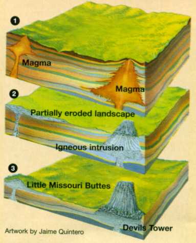
Evidence for this can be seen in Devils Tower National Monument, Wyoming. Devil's Tower -- a stock -- was created when a small body of intrusive magma cooled and eroded into its current shape -- at least that’s what they want you to think.3 Do you see the hexagonal shapes? Look at how flat the summit looks and how beautifully it curves up. Is it possible that the flat top was caused by humans logging these massive trees?1


If for some reason the following summary made no scientific sense: you are not alone. In refutation to the following paragraphs no “scientific” evidence was provided in Devils Tower formation. According to the USGS paper by Charles Robinson, “Geology of Devils Tower” Devils Tower was “formed by the intrusion of magma into the sedimentary rocks, and the shape of the igneous mass was formed by the cooled magma.”3 The tower is made of phonolite porphyry, an igneous rock similar in composition to granite but without quartz.3 Phonolite porphyry contains both phenocrysts and smaller crystals, containing aphanitic and porphyritic textures -- fast and slow cooling.4 Therefore, the only tree like feature about Devils Tower might be the “bushes” below. Even through all of this nonsense, it's worth wondering why Flat Earthers have had an impact at all.


Regardless of the scientific evidence that supports the creation of Devils Tower, Flat Earthers strongly deny these facts. Too bad there is only one rounded theory.


*Lyudin Rɣsi (I have no idea what it means)


Works Cited
  1. David Machina. "There Are No Forests on Flat Earth Wake Up." YouTube. YouTube, 01 Aug. 2016. Web. 02 Oct. 2016.
  2. Kriss, Sam. "Flat-Earthers Have a Wild New Theory About Forests." The Atlantic. Atlantic Media Company, n.d. Web. 02 Oct. 2016.
  3. Robinson, Charles Sherwood. "Geology of Devils Tower National Monument, Wyoming." USGS Publications Warehouse RSS. N.p., n.d. Web. 02 Oct. 2016.
  4. United States. National Park Service. "Geology of Devils Tower" National Parks Service. U.S. Department of the Interior, n.d. Web. 02 Oct. 2016.


Gneiss,Canadians Help to Further Understanding of Origins of Continental Crust

Geologists from the University of Alberta recently discovered a well-preserved specimen of super-old rock. This specimen is exciting because it provides evidence for hypotheses on how continental crust is formed, a process still not completely understood.  
         The Acasta Gneiss Complex in Canada’s Northwest Territory is home to some of the oldest rocks on earth. The Acasta Gneiss Complex was formed when a plume of mafic magma (characteristic of oceanic crust) pushed its way up into an older formation of granitic rock. The two rock types melted, mixed together, and cooled. As it cooled, zircon crystals formed. These zircon crystals allow scientists to precisely determine the age of the rock, which turns out to be some 4.02 billion years old.
          So why is the Acasta Gneiss Complex important? It is considered the oldest formation of craton on earth. Scientists have hypothesized that new continental crust forms under conditions similar to those exhibited in the Acasta Gneiss formation.
           The currently accepted hypothesis for continental crust formation can be summed up as follows: oceanic crust is melted, leading to chemical changes and separation of minerals in the melted rock. Some of these minerals are dense, and sink to become part of the mantle, but other minerals are more buoyant and rise. This rising magma comes in contact with preexisting granitic formations and the two melt and mix together. The Acasta Gneiss Complex cooled right in the middle of this process, leaving magma originally from oceanic crust incorporated into a granitic formation. Currently, this process is occurring in Iceland, where old rock from the island is melted along the mid ocean ridge and is metamorphosed into new rock, most of which is new continental crust.
                             Image result for continental crust formed from melted oceanic crust
            Aside from Iceland’s unique conditions, new continental crust is forming constantly along subduction zones. Oceanic crust slowly changes in composition when it is subducted, causing aforementioned denser minerals to sink and less dense minerals to rise. The less dense minerals pool at the bottom of the preexisting continental crust, where it continues to experience chemical changes while slowly cooling. This special magma melts granitic rock from the crust and the two mix together (listed in the figure as Contact Metamorphism). Eventually, this mixture cools and achieves the chemical characteristics of continental crust. Through this process new continental crust is slowly produced from the bottom up.
            The Acasta Gneiss provides valuable evidence for a process that is not well understood, as well as evidence for how the continents may have formed back in the early days of earth’s history.


 Sources

Weber, B. (2016, September 19). Rocks from the Northwest Territories shed light on Earth's earliest history - NEWS 1130. Retrieved October 01, 2016, from http://www.news1130.com/2016/09/19/rocks-from-the-northwest-territories-shed-light-on-earths-earliest-history/

Scientists uncover insights into the formation of Earth’s oldest continental crust. (2016, September 19). Retrieved October 01, 2016, from https://www.sciencedaily.com/releases/2016/09/160919121941.htm

Morford, S. (2016, February 22). How Does Earth’s Continental Crust Form? A New Bottom-Up Theory. Retrieved October 01, 2016, from
http://blogs.ei.columbia.edu/2016/02/22/how-does-continental-crust-form-scientists-have-a-new-bottom-up-theory/

Anonymous, (2013, March 15). The Acasta Gneiss: Earth’s Oldest Surface Rock. Science Buzz. Retrieved October 01, 2016, from http://www.sciencebuzz.org/blog/acasta-gneiss-earths-oldest-surface-rock