Tuesday, October 20, 2026

Do volcanic eruptions hold the key to fighting climate change?


In January of 2022, the submarine volcano Hunga Tonga-Hunga Ha'apai erupted. Located off shore of Tonga in the South Pacific, the eruption was one of the most violent of the modern era, and produced nearly 300,000 metric tons of methane into the atmosphere. Satellite images of the plume were taken and when the contents of the ash cloud were analyzed, researchers at the University of Copenhagen found something they hadn't expected. 

When a volcano erupts, it releases methane. Methane is about 80 times as potent as Carbon Dioxide, and responsible for one third of all global warming.

A study published in July of 2026 found that the plume from the Hunga Tonga-Hunga Ha'apai eruption not only contained methane and other expected gases, but also unexpectedly high amounts of formaldehyde. Formaldehyde forms temporarily when methane is broken down in the atmosphere. The presence of formaldehyde in the plume means that a process within the cloud actually broke down some of the methane that the eruption released, which has never previously been observed within a stratospheric volcanic plume. 


Figure 2: contents of Hunga Tonga-hunga Ha'apai plume


In 2023, a reaction between volcanic ash, seawater, and sunlight was observed that similarly decreased methane levels, but the Hunga Tonga-Hunga Ha'apai reaction took place under very different physical conditions because of its atmospheric height. 

In the ongoing fight against climate change, scientists are constantly looking for naturally occurring processes that can be harnessed to decrease greenhouse gases from the atmosphere. Methane is unique from other greenhouse gases like carbon dioxide in both its potency and the fact that it only stays in the atmosphere for about ten years before naturally breaking down. Both of these factors mean that targeting methane will lower warming rates much more quickly than targeting CO2. Discussions on the viability of plans involving the harnessing of the reaction that took place at the Hunga Tonga-Hunga Ha'apai reaction are ongoing, and it is exciting to see how geological processes can be used in the environmental movement.


Works Cited 

Bassi, M. (2026, June 4). Tonga’s enormous volcanic eruption cleaned up part of its own methane emissions in 2022, hinting at a way to fight climate change. Smithsonian Magazine. https://www.smithsonianmag.com/smart-news/tongas-enormous-volcanic-eruption-cleaned-up-part-of-its-own-methane-emissions-in-2022-hinting-at-a-way-to-fight-climate-change-180988893/


van Herpen, M. M. J. W., De Smedt, I., Meidan, D., Saiz-Lopez, A., Johnson, M. S., Röckmann, T., & de Laat, J. (2026). Satellite quantification of enhanced methane oxidation applied to the stratospheric plume following hunga Tonga-hunga ha’apai eruption. Nature Communications, 17(1). https://doi.org/10.1038/s41467-026-72191-4


Sunday, October 18, 2026

Surging Glaciers: the Hidden Threat of Accelerating Glaciers

     While most glaciers nowadays are known to be shrinking as a result of global warming, there is a small group of glaciers that are actually surging forward, causing environmental disasters in their surrounding areas. 

    A surging glacier is when a typically slow-moving glacier rapidly begins to speed up by pushing large amounts of ice in front of the glacier, causing it to advance. When a glacier surges, it accelerates from moving a few inches per day to moving tens of meters per day and can reach a peak of up to 60 meters per day. 

Image: A Surging Glacier Landsystem

    A recent study (published in Nature Reviews Earth and Environment) found that there have been over 3,100 glaciers that have experienced these glacial surges. The glaciers that experience these glacial surges are typically located in the Arctic, High Mountain Asia, or in the Andes Mountains.

    These surging glaciers are actually found to be more vulnerable to climate change; while surging, the glacier can lose large masses of ice, causing a large proportion of ice mass loss in the surrounding region. Additionally, climate change is making these glaciers more unpredictable; as climate change affects the climate in different areas of the world, the locations of where these glacier surges are occurring could spread to other areas and could stop occurring in the current regions of the Arctic, High Mountain Asia, or in the Andes Mountains.

    These glaciers can cause various hazards in the surrounding areas: they can block rivers, create floods caused by meltwater release, cause widespread crevassing, release icebergs, and glacier advance can impact infrastructure.

Photo: The Black Rapids Glacier, which moved almost 6.4 km (4 miles) in four months during its surge from 1936-1937


Works Cited
Flowers, Gwenn, and Simon Fraser. “Scientists warn of 3100 “surging glaciers” that can trigger floods and avalanches.” Science Daily, https://www.sciencedaily.com/releases/2026/04/260416071958.htm. Accessed 18 October 2026.
“Glacier surging and surge-related hazards in a changing climate.” Nature, https://www.nature.com/articles/s43017-025-00757-9. Accessed 18 October 2026.
“Global analysis tracks 3,100 glacier surges as climate change rewrites the rules.” Phys.org, https://phys.org/news/2026-02-global-analysis-tracks-glacier-surges.html. Accessed 18 October 2026.
Lovell, Harold, and Chris Stokes. “Glaciers Can Suddenly And Dangerously Surge Up to 60 Meters a Day.” Science Alert, 19 February 2026, https://www.sciencealert.com/glaciers-can-suddenly-and-dangerously-surge-up-to-60-meters-a-day. Accessed 18 October 2026.
Wilson, P. R., and D. H. Mann. “Prehistoric Surges of the Black Rapids Glacier, Alaska: Using the Past to Assess Future Hazards.” American Geophysical Union, December 2019, https://ui.adsabs.harvard.edu/abs/2019AGUFM.C41D1495W/abstract. Accessed 18 October 2026.


Sunday, October 4, 2026

Volcanoes and Earthquakes in Costa Rica

    Costa Rica is renowned for its biodiversity and dramatic landscapes, shaped over millions of years by intense volcanic activity. Costa Rica has 61 identified volcanoes, only five are active today. Among these volcanoes, Rincón de la Vieja stands out as the most frequently active.


    Rincón de la Vieja is located on the northwestern side of Costa Rica and is estimated to be 1 million years old. The volcano reaches 6,217 feet above sea level and there is only one active vent which has an acidic crater lake in the middle, Von Seebach. Rincón de la Vieja has been the most active for the last few months but there has also been changes in earthquakes in the surrounding area. 

Costa Rica sits on the Caribbean Plate and near the subducting Cocos Plate, additionally Costa Rica lies on the Ring of Fire. Just about everyday there are earthquakes in Costa Rica ranging on average from 3-4.5 magnitude depth. The earthquakes do not necessarily indicate that there will be a major eruption soon, the volcano is currently classified at a precautionary level. 


    Scientists have recorded many changes in the volcano during September. In a span of three days there were 123 small earthquakes near the crater. The volcano also rose 13 millimeters in a 27-day period. Additionally, there has been an increase in the production of sulfur dioxide, previously being about 200 metric tons per day but now it reaches about 2,000 metric tons. It was also recorded that over 10 days there had been 67 small eruptions. 


The collective data gathered from Rincón de la Vieja during September paints a picture of a dynamic hydrothermal system reacting to deep-seated magmatic activity. The convergence of micro-earthquakes, localized ground inflation, rapid gas production, and frequent low-level eruptions illustrates how magma movement drives changes at the surface. While these parameters confirm that Rincón de la Vieja is experiencing a period of unrest, regional seismic norms and constant monitoring reinforce that precautionary measures are the appropriate scientific response. Continuous observational data remains Costa Rica’s best tool for understanding and safely living alongside its most active volcano.


Works Cited

“Global Volcanism Program | Rincón De La Vieja.” Smithsonian Institution | Global Volcanism Program, volcano.si.edu/volcano.cfm?vn=345020. Accessed 2 Oct. 2026.

The Tico Times. “Costa Rica’s Rincón De La Vieja Shows Signs of Stronger Eruptions.” The Tico Times | Costa Rica News | Travel | Real Estate, Oct. 2026, ticotimes.net/2026/10/01/costa-rica-rincon-de-la-vieja-stronger-eruptions. Accessed 2 Oct. 2026.

Sunday, September 27, 2026

Shallow Vs. Deep Subducting Slabs


    Recent studies released in April 2026 indicate that the shallowness of a subducting slab is the reason for the increasing intensity of shaking during mega-thrust earthquakes in the Cascadia region. Elsewhere, the movement of deeply subducted tectonic plates has been recognized for deforming the material of the mantle itself. The overall movement of subducting slabs has been shown to have significant effects on the Earth, not only by causing earthquakes but also by deforming the lower levels of the mantle.


Deep mantle anisotropy and induced by a sinking slab leading to crystal alignment 

    Research performed during 2021 to 2022 on seismic activity offshore from Vancouver Island to northern California revealed that earthquakes occurring due to subducted tectonic slabs closer to the surface tend to cause more intense and disruptive shaking compared to earthquakes resulting from subducted tectonic slabs at deeper levels. This is particularly relevant to the shallow Juan de Fuca slab, which shows potential to produce more intense ground shaking. During the 2026 Seismological Society of America meeting, it was revealed that the Juan de Fuca slab interface estimation was around 5 kilometers shallower than previously believed, a difference that could increase ground shaking by 9 to 17%.


    In terms of deeply subducted tectonic plates, new studies by The Seismic Record researchers confirm that the deformation in the lowest level of the mantle occurs where deeply subducted tectonic plates would be. It is a known fact that the deformation in the upper mantle is dominated by the plates that move across it; however, understanding the deeper mantle and the flow of it is being discovered using a seismogram database. This database is quoted to be “the largest-ever assemblage of earthquake seismic data.” They used seismic anisotropy, which analyzes how seismic waves produced by earthquakes vary depending on their path, to find out more about the lower mantle. It was discovered that anisotropy occurs in about two-thirds of the sampled lower mantle, and especially where there was believed to be subducted slabs. The seismic anisotropy is likely caused by deformation that they face when they arrive at the core mantle, however, it is also known that the slabs hold traces of anisotropy from their time close to the surface as shallow subducting slabs.


All in all, recent research has revealed that the depth of subducting slabs has an incredible influence, subducting slabs at both deeper and shallower levels reveal different perspectives on how plate tectonic movement impact our world, may that be in the mantle, or right under our feet.


Bibliography:


Press, S. (2026, April 15). New Look on Subducting Plate Near Oregon Coast Suggests Increased Shaking During Megaquake | Seismological Society of America. Seismosoc.Org. https://www.seismosoc.org/news/new-look-on-subducting-plate-near-oregon-coast-suggests-increased-shaking-during-megaquake/

SSA Press. (2026, April). Global map shows deep mantle deformation is linked to subducted slabs. Seismosoc.Org. https://www.seismosoc.org/news/global-map-shows-deep-mantle-deformation-is-linked-to-subducted-slabs/


Thursday, September 24, 2026

High-voltage Transmission Line Threatens Driftless Region's Geology

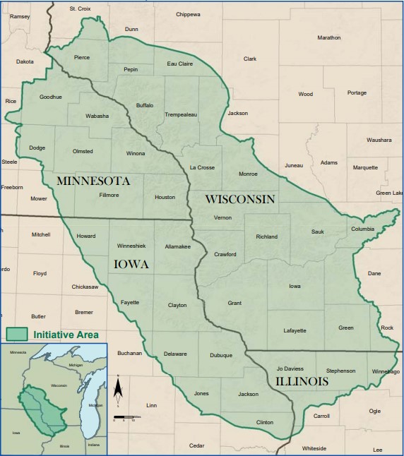
    The Driftless Region has a unique history due to the ice age. The name itself comes from the fact it remained untouched by the moving glaciers, preserving deep valleys and steep bluffs. Wisconsin has more than 75% of the Driftless Region within its state borders. 
Top: map of the Driftless Region
Bottom: picture of a Driftless Area in Verona, WI

    This is due to the glaciers being blocked by the highlands of northwestern Wisconsin. Troughs-depressions in the Earth's surface-created by Lake Michigan and Lake Superior also helped the glaciers move away from this area and into rivers. The glaciers melted for the last time 13,000 years ago, causing massive quantities of water to erode the sedimentary rocks and carve the land we know today.

    Sadly, this ancient landscape is under attack by a corporation seeking to place a transmission line that would go into the Driftless Region. The argument for the line would be to increase the electricity that would be available to those in the region. Opposition has started in communities that would be affected by the line, saying it will transport electricity across the region but not to them. It would also change the communities, cause environmental harm, and increase electricity bills. Lodi, Wisconsin is one of those communities.

    "'I don't think it's an exaggeration to say that if a line were to run though this 40-parcel, it would destroy the opportunities that we have here for our students,'" said Paula Tonn, a Lodi School Forest Committee member. The school has been around for 90 years, teaching kids forestry, invasive species, and ecosystem. management. It would be a loss to the kids and community if the line were to go through this area.

    The issue is uniting those across the political spectrum as well. Democrats and Republicans in the legislature have voiced opposition to the line, with some signing a letter to the company to postpone plans until more meetings can happen in the spring. With more attention being drawn to this issue, the line is planning to be installed in 2033.

“About the Driftless Area.” Eagle Bluff Environmental Learning Center, Eagle Bluff, 17 Aug. 2026, eaglebluffmn.org/driftless/. 

Dabruzzi, Anthony. “Lodi School Leaders Raise Concerns over Proposed Transmission Line.” Lodi School Leaders Raise Concerns over Transmission Line, 14 Sept. 2026, spectrumnews1.com/wi/milwaukee/news/2026/09/14/proposed-transmission-line-concerns. 

“No 765 Line - Stop the 765 kV Lines across Southern Wisconsin.” Https://No765line.Org, The Board, 28 May 2026, no765line.org/. 

Sunday, September 20, 2026

A Mammoth Under Every Corner

Most places, one can’t start digging and expect to stumble across a mammoth. Then again, the humble college town of Corvallis, Oregon is not “most places”.

In 2021, while digging along Corvallis’ 9th Street in preparation for a natural gas pipeline, construction crews were understandably confused when their excavator came up coated with a chalky white material that didn’t match the surrounding rock. First, Public Works was called and, when it was found to be a mammoth tusk, OSU stepped in. The following summer an anthropologist and his graduate students excavated as much as they could and sent it to the lab to dry.

It ended up being a Columbian mammoth tusk, and it was roughly 12,700 years old. The excavator had unfortunately cut through it, but it was still remarkably complete, potentially even beyond the tusk itself; during excavation, it was noted that the fossil material seemed to go further into the road. The mammoth the tusk belonged to still lies under the road today. The tusk itself, once dry, has been displayed in the public library since August 21st, 2026.


The 2021 tusk’s display case in the library

Nor is this the first time this has happened.

In 2016, while constructing new locker rooms under OSU’s Reser Stadium, the crew found a 4-foot-long femur that belonged to another Columbian mammoth. As more digging ensued, more bones were found—a veritable multitude of bone fragments from extinct bison, camels and mammoths. Ground-penetrating radar hinted at more bones leading towards the parking lot; however, these have never been exposed.

Still earlier, in 2012, parts of a mastodon jawbone were found while building housing in northeast Corvallis. This find was a lot more fragmentary than the other two, and the backhoe had knocked some teeth out, but those teeth were still complete enough to be identified. 

While the surrounding paleontological landscape has not been identified for two of the three discoveries, it makes perfect sense that the Reser Stadium find existed. The ravaging Missoula Floods, occurring when the massive glacier lake Missoula repeatedly overflowed its melting ice dam, saturating the Willamette Valley with water. The soil has been wet since, hence why the 2021 tusk had to dry prior to display, and the whole valley is full of of rivers, lakes and ponds. Flood deposits along the site hint that the Stadium was once a bog along a stream bed, where elderly or ailing animals would have come to die. The ancient stream continued towards the parking lot, running amongst the undug bones.

Corvallis’ location at the time of the Missoula Floods.


With three major discoveries and hints of more to find, it’s fair to assume that Corvallis will yield more fossils. And if recent history is any guide, construction crews will bring them to light. 


References: 

Klampe, M. (2017, April 11). Emissary from an ice-age boneyard. Oregon State University Terra Magazine. https://terra.oregonstate.edu/2017/04/emissary-ice-age-boneyard/ 

Mid-Valley Media Group. (2012, February 24). Mastodon jaw unearthed in Corvallis. YouTube. https://www.youtube.com/watch?v=rIvitz_TfZ0 

Moore, M. (2026, August 26). Prehistoric pedestrians once walked 9th Street in Corvallis. Now, you can see proof at the library. KLCC. https://www.klcc.org/human-interest/2026-08-18/corvallis-library-mammoth-tusk-display 

Profita, C. (2016, January 28). Ancient mammoth bones discovered under Oregon State’s stadium. PBS. https://www.pbs.org/newshour/science/ancient-mammoth-bones-discovered-under-oregon-states-stadium 

Ridenour, G. J. (2025, August 15). Geoarchaelogical investigations at OSU South Farm: Locating buried pleistocene and Holocene deposits in the Willamette Valley, Oregon. https://ir.library.oregonstate.edu/concern/graduate_thesis_or_dissertations/gb19fg12f. 

Wednesday, December 7, 2022

Anagenesis in Tyrannosaurs: the Discovery of Daspletosaurus Wilsoni

A new fossil has been discovered in Montana. Daspletosaurus Wilsoni, is a large Tyrannosaur thought to be closely related to Tyrannosaurus Rex. However D. Wilsoni is not just another fossil, it is evidence for a changing evolutionary perspective on Late Cretaceous North American dinosaurs. This is because D. Wilsoni might show evidence of anagenesis in Tyrannosaurs. What does this mean and why is it significant you may ask? 

Well, let's start with some background, what are Tyrannosaurs? Tyrannosaurs are a group of large predatory theropods which dominated the Northern hemisphere during the Late Cretaceous. Basically anything closely related to T. Rex. The issue with Tyrannosaurs is that we don’t really know how they came to be. Their ancestors were small, walking in the shadows of larger theropods like Acrocanthosaurus. We know that these small theropods evolved into giants like T. Rex but how is it a bit trickier to answer. 

Enter D.Wilsoni, a new species of Tyrannosaur. Wilsoni is a species of Daspletosaurus, an older Tyrannosaur (around 76 million years old) and was the apex predator in North America before T. Rex. It was big, although not quite as big as its more famous cousin, and with the discovery of D. Wilsoni, it poses some interesting questions on the evolutionary history of Tyrannosaurs. 

D. Wilsoni does not answer the question of how the relatively small Tyrannosuroids became the huge apex predators that Tyrannosaurs represent, but it does answer how those Tyrannosaurs evolved. D. Wilsoni is a mishmash of characteristics, it has primitive horns, but derived eye sockets. This places it as somewhat of an evolutionary middle ground between older and younger species of Daspletosaurus. This indicates that Tyrannosaurs were following an anagentic evolutionary pattern. This means that one species essentially replaced another, rather than the more common cladistic model where many evolutionary cousins evolve roughly contemporaneously. The impact of this is very important to Tyrannosaur evolution and possibly points to Daspletosaurus directly evolving into T.Rex. 


Works Cited: 


D'Emic, M. D., Melstrom, K. M., & Eddy, D. R. (2012). Paleobiology and geographic range of the large-bodied cretaceous theropod dinosaur acrocanthosaurus atokensis. Palaeogeography, Palaeoclimatology, Palaeoecology, 333-334, 13–23. https://doi.org/10.1016/j.palaeo.2012.03.003  

staff, S. X. (2022, November 28). New species of tyrannosaur, daspletosaurus wilsoni, hints at ancestor of T. Rex. Phys.org. Retrieved December 5, 2022, from https://phys.org/news/2022-11-species-tyrannosaur-daspletosaurus-wilsoni-hints.html 

Ravisetti, M. (2022, December 2). 76 million-year-old fossil settles paleontology debate over T. Rex history. CNET. Retrieved December 5, 2022, from https://www.cnet.com/science/biology/76-million-year-old-fossil-settles-paleontology-debate-over-t-rex-history/