Tuesday, October 4, 2022

A Reminder from Lake Mead

Due to the climate crisis, the record-low water levels at Lake Meat constantly decrease. The decreasing water levels not only expose sunken boats and human remains, but also sedimentary rocks that have not been seen since the 1930s. 

Through studying these sedimentary rocks, Geologists from the United State of Nevada, Las Vagas discovered that volcanic ash originated from as far as Idaho, Wyoming, and California and rained down on Nevada12 million years ago. Based on this study, the UNLV College of Sciences’ Cryptotephra Laboratory for Archaeological and Geological Research (CLAGR) team emphasized the importance of paying attention to not only the safety of people who live on the lava-flow path of active volcanoes but also the people who live far away from the volcanoes.

Eugene Smith, an emeritus professor of geology from UNLV said: “Although the Las Vegas Valley is currently very far away from any active volcanoes, we can and will have ash from these volcanoes fall over Southern Nevada in the future.” 


When the volcano erupts, the magma is pushed up into the air, cools down, and becomes volcanic rock and glass fragments. Besides, the force of eruption shatters the rock from volcanoes. These small particles also become part of the volcanic ash. Since the ash is light and small, the wind can bring them to places thousands of kilometers away from where the eruption takes place. 

                                              Towns around Indonesian mountains are covered by volcanic ash in Nov, 2010

In the air, once the ash gets into the airplane, the minerals may melt in the engine and solidify on the turbine blade, which makes the engine stall. To humans, the particles in the ash can scratch the surface of the skin and eyes. If it is inhaled, the ash can cause breathing issues and lung diseases such as silicosis. More seriously, it leads people to choke. In addition, once the weather is wet, the ash becomes paste likes cement, and it is very heavy which can break infrastructure and bring the city to a standstill.


References:

“The Geologic Secrets of Lake Mead”. EurekAlert!, www.eurekalert.org/news-releases/966032.

“Lake Mead's Shrinking Shoreline Exposes Volcanic Ash as Old as 12 Million Years, Study Finds.” MSN, www.msn.com/en-us/weather/topstories/lake-meads-shrinking-shoreline-exposes-volcanic-ash-as-old-as-12-million-years-study-finds/ar-AA12jVMn.

“Human and Environmental Impacts of Volcanic Ash." National Geographic Society, education.nationalgeographic.org/resource/human-environmental-impact-volcanic-ash. 

Monday, October 3, 2022

Natural Disaster Reveals Natural Treasure

Alaska coast 8.2 earthquake was the strongest one in decades, official says  | CNNIn July 2021, Alaska got shaken up with an 8.2 magnitude earthquake. Paleontologist Tony Fiorello visited this location this summer and discovered an additional number of new prints along with the over 30 new dinosaur footprints from 3 different species, discovered by paleontologists since the earthquake. Among these footprints were ankylosaur and theropod. The footprints that were found date back to the late Cretaceous and are mostly from Hadrosaurs. Fiorello has been studying this section of Alaska since 2002 and has worked to try to reconstruct the ancient environment. He is focusing his work on a 300 m thick chunk of sediment. Fiorello has been able to date this section of rock, but what he is really interested in is how the climate in this area changed starting 75 million years ago. The 2021 earthquake uncovered a load of dinosaur footprints in the area. The discovery of these new footprints allows Fiorello to better understand the ancient environment by looking at what animals were walking around in what environments and when. Fiorello and his team have just begun to analyze their data, and plan to present their findings at the Geological Society of America meeting that starts this coming Sunday (which I will actually be at!). These new findings have the potential to open up a new wealth of knowledge for the geologic and paleontological communities.


Works Referenced

Schwing, Emily. “A Quake May Have Uncovered 30 New Dinosaur Tracks in Alaska.” The Washington Post, WP Company, 29 Sept. 2022, https://www.washingtonpost.com/science/2022/10/01/alaska-earthquake-dinosaur-tracks/. 


Holcombe, Madeline, and Joe Sutton. “Alaskan Coast 8.2 Magnitude Earthquake Was the Strongest One in Decades, Official Says.” CNN, Cable News Network, 29 July 2021, https://www.cnn.com/2021/07/29/us/alaska-earthquake-8-2/index.html. 


Sunday, October 2, 2022


Geoarchaeology in Action

Geology has enabled scientists to discover an entirely new species of hominid in Denisova Cave, Siberia.

What is Geoarchaeology?

Geoarchaeology is a branch of geology that employs knowledge of geology and Earth systems in order to investigate archaeological questions. While archaeologists may inspect an artifact extracted from the earth, geoarchaeologists are more concerned with studying the sediment around it. Through this study, geoarchaeologists are able to provide archeologists and anthropologists with vital data. The sediment surrounding an artifact provides context into the climate, general environment and even geography that the artifact was created in. In addition, geoarchaeologists are able to track how the surrounding sediment may have influenced the artifact itself. For example, if archeologists were to unearth a piece of red bone jewelry from a site, geoarchaeologists may be able to inform them that the jewelry did not originally have that particular color, rather the sediment around it containing iron oxide gave the jewelry a red hue. Recently, geoarchaeologists have made bold steps in their field, opening up the possibility of extracting even more interesting information from the sediment they study: DNA.

Left: Map of Denisova Cave, Right: Cave entrance

Sources: Natture.com, Science Insider-Richard Rogers

Denisova Cave

Geoarchaeologists suspected Denisova Cave in Siberia was once home to several species of hominid, including homo sapiens, or modern humans. Their objective was to be able to trace the inhabitants of the cave from 300,000 years ago. They were not disappointed. By digging into the floor of the cave and analyzing samples from the remarkable sediment stratification, the scientists were able to determine the DNA of many creatures that inhabited the cave over the past 300,000 years. Some are animals such as wolves, hyenas and bears, but three distinctive human species emerged from the vast array of DNA samples acquired. These three species are modern humans (homo sapiens), who lived in the cave from 80,000 years ago, Neanderthals (homo neaderthalensis), and a new species of hominid previously unknown. This new species was named the Denisovan (homo Denisova), and the coexistence of the DNA with that of modern humans and Neanderthals has shifted the way that scientists consider the interaction of ancient hominid species.

300,000 years of stratification in Denisova Cave

Source: Chemical Engineering News (American Chemical Society) : Javier Trueba/Madrid Scientific Films

By evaluating DNA, geoarchaeologists are able to track which populations of which hominid existed, or in some cases coexisted, in Denisova Cave at various points. The Denisovans lived in the cave on and off between 250,000 years ago and 60,000 years ago. In addition, the geoarchaeologists are able to effectively evaluate how changes in climate altered these populations and led to the prevalence of a particular species over another at different points in ancient history. Interestingly, some sediments hold onto DNA better than others, geoarchaeologists have already identified calcite grains as being excellent for preserving DNA as it “sticks” to the grooves of cleavage of a calcite crystal. Climate also affects the way that DNA is preserved. In tropical regions, it is more unlikely to get a complete genome than in temperate regions. Evaluating DNA as a method of dating extends much farther back than radiocarbon dating is capable of doing, as radiocarbon dating caps out at about 50,000 years into the past. 

The work of geoarchaeologists combines geology, chemistry, biology, anthropology and archeology to create a unique area of study and one that provides insight into our shared human past.

Works Cited:

Brazil, Rachel. “Digging up DNA after Tens of Millennia.” C&En Chemical Engineering News, American Chemical Society, 30 Aug. 2022, https://cen.acs.org/analytical-chemistry/sequencing/Digging-DNA-tens-millennia/100/i31.

“Geoarchaeology.” University of Wollongong, University of Wollongong, Australia, https://www.uow.edu.au/science-medicine-health/research/centre-for-archaeological-science/research-themes/geoarchaeology/.

Long, Ben. “DNA from Sediment Reveals Epic History of Denisova Cave.” Phys.org, Phys.org, 23 June 2021, https://phys.org/news/2021-06-dna-sediment-reveals-epic-history.html.

Wong, Kate. “Cave That Housed Neandertals and Denisovans Challenges View of Cultural Evolution.” Scientific American, Scientific American, 30 Jan. 2019, https://www.scientificamerican.com/article/cave-that-housed-neandertals-and-denisovans-challenges-view-of-cultural-evolution/.


Zhangjiajie: A Masterpiece of Nature

     Zhangjiajie lies in the southern China Plate and a humid subtropical climate zone. The geological formation of Zhangjiajie belongs to the New Cathaysian tectonic system. About three billion and eight thousand years ago, the area was a large patch of ocean. After a series of geological changes, including Wuling-Xuefeng, Indo-China, Yanshan, Himalayan, and Geotectonic movements, the bottom of the ocean rose through the surface, and the quartzite sandstone pillars and peaks took shape after gradual cutting, eroding, and crumbling by the force of Nature for millions of years. The entire area is covered with towering cliffs of sandstone of quartz and dense unspoiled forests that conceal fantastic caves full of stalactites and stalagmites.


    The formation of Zhangjiajie Landform is complex. It was an ocean at first, but it became land around 350 - 290 million years(late Devonian Period). After the long-term weathering of sandstone, a red weathering crust-iron hat was formed. Around 290 - 200 million years ago, the lowered crust changed the Zhangjiajie area into the sea again with the deposition of limestone. Around 200 million years ago Zhangjiajie area was lifted and changed into land. The previously formed limestone occurred on the surface. Zhangjiajie area left the marine environment ever since. Around 180 to 80 million years ago, Yanshan Movement caused the fracture and deformation of rocks in the Zhangjiajie area. Many inside joints and fractures in the rocks were formed. It provided conditions for weathering and fluvial incision. Around 65 to 30 million years, the crust was relatively stable. The raised mountain experienced weathering, denudation, filling, and leveling up. Around 23 to 2.6 million years (Neogene Period to Early QuaternaryPeriod), the Himalayan Movement led to the intensive lifting of the Zhangjiajie area. The constant undercut of rivers was stopped by “Iron hat ” and shifted to lateral erosion and broadening. The neotectonics over 2.6 million years uplifted the crust in the Zhangjiajie area. Running water along the joints and fissures cut the quartz sandstone into the landforms like mesas, tablelands, peak walls, peak forests, and single-peak groups.


    Zhangjiajie is described as “beautiful girl” in China. In the Tianzi Mountain of Zhangjiajie, you'll find crescendos of sandstone rock steeples buried deep in the ground below. In a dreamlike stone forest, the surreal juxtaposing spirals are especially impressive in the “Sea of Clouds”. Shen Congwen, a famous writer, described Zhangjiajie thus: “Entering western Hunan Province, all the sights are quietly beautiful with a bit of melancholy. Depicting any section would require a good painting from the Song Dynasty. Everything is pure poetry.”

    I believe that nature is the greatest creator in the world. All the factors in nature influence each other, and changes occur all the time. Although the processes might be invisible to us, we can see the miracle created by the nature.


Citation

Geography of zhangjiajie, China. Brand. (n.d.). Retrieved October 1, 2022, from        

https://www.zhangjiajietourguide.com/article-p268-geography-of-zhangjiajie.html

Landform of zhangjiajie - zhangjiajie tour guide, China. Brand. (n.d.). Retrieved October 1, 2022, from                

https://www.zhangjiajietourguide.com/article-p263-landform-of-zhangjiajie.html 

Wu, M. (n.d.). China's efforts to help solve the crisis in Syria can withstand test of time. Zhangjiajie

A Wonder of the World. Retrieved October 1, 2022, from:

http://www.chinatoday.com.cn/ctenglish/se/txt/2009-01/21/content_175438.htm  

Kontis, N. (2020, January 2). Zhangjiajie, China: Get hyped for 'avatar 2' by visiting the place that     

inspired the film. USA Today. Retrieved October 1, 2022, from 

https://www.usatoday.com/story/travel/destinations/2019/12/17/zhangjiajie-china-experience-mountains-inspired-avatar/2663739001/ 

Saturday, October 1, 2022

Balkanatolia: Forgotten Continent

A team of geologists and paleontologists rediscovered a forgotten low-lying continent from 40 million years ago, and it may have served as a bridge allowing Asian mammals to inhabit Western Europe. This forgotten continent was named 'Balkanatolia' since it occupied areas corresponding to the present-day Balkans and Anatolia. 


Geographical changes in 40 to 34 Ma connected this continent to its two neighbors, Europe and Asia, paving the way for the replacement of European mammals by Asian mammals. 


For millions of years during the Eocene Epoch (55 to 34 Ma), Western Europe and Eastern Asia formed two distinct landmasses with very different mammalian faunas. However, in the early Oligocene (33.9 to 33.4 Ma), mammals from the two areas suddenly met due to glaciation and sea-level drop. The Asian mammals eventually replaced the western species via predation and competition. Researchers deduced this by using fossils of Asian taxa-like ungulates (hoofed mammals) found in Europe. This event was termed the Grande Coupure (the “big cut”), which refers to Western Europe being colonized by Asian species, leading to a major renewal of its biodiversity. 


However, fossils of Asian mammals in the Balkans suggested that some Asian fauna began to colonize Europe up to 10 million years before the Grande Coupure, suggesting earlier colonization. 


The scientists reviewed earlier paleontological discoveries, which revealed that for much of the Eocene, Balkanatolia could've been a separate landmass that served as a stepping stone for animals to travel from Asia into Western Europe. It’s likely that a major glaciation 34 Ma lead to the formation of the Antarctic ice sheet and lowered sea levels, connecting Balkanatolia to the European mainland. 


Balkanatolia contains many secrets awaiting to be uncovered, not only in terms of cataloging mammalian faunas but also in discovering more of its rise and fall. Researchers will just have to keep digging. 


Sources:

Cnrs. “Balkanatolia: Forgotten Continent Discovered by Team of Paleontologists and Geologists.” SciTechDaily, March 4, 2022. https://scitechdaily.com/balkanatolia-forgotten-continent-discovered-by-team-of-paleontologists-and-geologists/. 

Science X. “Balkanatolia: The Forgotten Continent That Sheds Light on the Evolution of Mammals.” Phys.org. Phys.org, February 21, 2022. https://phys.org/news/2022-02-balkanatolia-forgotten-continent-evolution-mammals.html. 

World. “Balkanatolia: The Details Revealed by Experts of the Continent Lost about 40 Million Years Ago.” CVVNEWS, March 13, 2022. https://cvvnews.com/balkanatolia-the-details-revealed-by-experts-of-the-continent-lost-about-40-million-years-ago/. 


Monday, September 26, 2022

Pakistan extreme flooding, caused, in part, by glaciers. What’s next?

One-third of Pakistan was underwater as of Sep. 2022. While some amount of flooding has become typical after monsoon rains during the summer, flooding this year was devastating to the people of Pakistan (Rascoe). One reason why the flooding was more extreme, is melting glaciers (Rascoe).

Glaciers are immensely important to high alpine environments, where they are the main source of freshwater. Fauna and flora depend on the melted glacier water, also known as meltwater (Rascoe). In simple terms, a glacier is a large mass of ice, moving on a slope. The glacier can either be on a steep slope like in the mountains, or on a shallow slope such as in Greenland. In high altitudes, snow falls as precipitation, and the glacier grows. It becomes heavier before it begins to move down towards lower elevation areas where it either melts or evaporates into the atmosphere through sublimation (Rascoe). As glaciers move downwards to low-altitude areas, it drags along rocks, sediment, and other bits of debris. As it drags the material, it scratches and grinds the bedrock beneath the glacier, which is called abrasion (How glaciers change the landscape). As it melts, the glacier releases the materials. When pre-existing cracks in the bedrock grow underneath the glacier, large pieces of rock break free and are carried by the glacier (How glaciers change the landscape). As a cycle each year, glaciers grow and melt, changing the bedrock underneath them, and transporting materials. 

In May, a bridge in Pakistan collapsed due to flash flooding caused by a quick release of water from a glacier-fed lake, also called a glacier lake outburst (Fox).

Besides the Arctic and the Antarctic, Pakistan has the most glaciers in the world, over 7200 (Rascoe). In the past, glaciers melt before the monsoon season in Pakistan, creating two peak flood seasons. Climate change is adding two factors to the glacier melt and monsoon seasons. First, climate change is causing the monsoon season to move up in the calendar year, becoming closer to the snowmelt season (Rascoe). In the case of this year, they overlap, creating extreme flooding. Second, climate change is increasing the number of glaciers melting each year. Globally, from 2015 to 2019, there were 70 billion more tons of ice that melted every year in comparison to the period from 2000 to 2004 (Rascoe). As climate change worsens, more of the glaciers melt, and the cycle eventually stops. Small glaciers will form each winter and entirely melt in the summer. 

While the glacier melting in Pakistan is causing political and economic hardship in the country, the glacier melting in Greenland is predicted to have more of an impact on the world as a whole. It is expected that the glacier melting in Greenland, alone, will cause sea levels to rise at least 10.6 inches (Cho). If climate change continues to worsen at the same level as it is, glaciers in Greenland would be responsible for at least 30 inches of sea level rise (Cho). Melting glaciers from the rest of the world would only worsen this outcome.

The left diagram demonstrates the total amount of days that the glacier has melted in the year, to date. The right diagram shows the amount of glacier melt in the previous day (National Snow and Ice Data Center).

What will happen once glaciers melt entirely? In the Arctic, where the glaciers could disappear as early as 2035, the region would be more accessible to material transporting, fossil fuel extraction, and mining (Cho). The United States Geological Survey estimated that 30% of undiscovered gas and 13% of undiscovered oil is within the Arctic Circle, currently underneath ice (Cho). Essentially, the more ice that melts each year, the more of an opportunity is created for climate change to worsen by increasing the amounts of mining, fossil fuel extraction, and exposing ecosystems to human harm. 

A few arguments are important to address in combination with concerns about glacier melting. First, there is the reality that as new shipping routes are opened by melting glaciers, time spent transporting material would decrease (Cho). Specifically, ships could cut through the Arctic, decreasing their emissions by 24% (Melting arctic ice could transform international shipping routes, study finds). In addition, many different precious metals are needed for countries to transition to renewable and clean energy, which could be mined in oceans once covered by glaciers (Cho). Melting glaciers also release historically and geologically significant information such as preserved artifacts.

Even though there are a few small positive outcomes to melting glaciers, the positives do not overpower the negatives of the issue. Climate change is interrupting the process of glaciers growing, changing the bedrock underneath, and melting. As a long term result, sea levels are rising, but on a short term basis, countries such as Pakistan are under political and economical pressure due to receiving the bulk of the impact.

Sources

Cho, Renee. “What Lies beneath Melting Glaciers and Thawing Permafrost?” State of the Planet, Columbia Climate School: Climate, Earth, and Society, 13 Sept. 2022, https://news.climate.columbia.edu/2022/09/13/what-lies-beneath-melting-glaciers-and-thawing-permafrost/.

Fox, Kara. “Pakistan's Melting Glaciers Are 'Erupting' and Worsening Floods.” CNN, 2 Sept. 2022, https://www.cnn.com/2022/09/01/asia/pakistan-flooding-glacier-outbursts-climate-intl/index.html.

“How Glaciers Change the Landscape.” National Parks Service, https://www.nps.gov/articles/howglacierchangethelandscape.htm#:~:text=Glacial%20Deposition&text=Glacier%20can%20also%20shape%20landscapes,it%20flows%20over%20sediment%20beds.

“Melting Arctic Ice Could Transform International Shipping Routes, Study Finds.” ScienceDaily, 20 June 2022, https://www.sciencedaily.com/releases/2022/06/220620152119.htm.

“National Snow and Ice Data Center.” NSIDC Arctic News and Analysis RSS, 12 Sept. 2022, http://nsidc.org/greenland-today/.

Rascoe, Ayesha. “How Melting Glaciers Contributed to Floods in Pakistan.” NPR, 4 Sept. 2022, https://www.npr.org/2022/09/04/1120952641/how-melting-glaciers-caused-by-climate-change-led-to-to-floods-in-pakistan.

Sunday, September 25, 2022

What Happens If We Send Our CO2 Down Rather Than Up?

Human emissions of greenhouse gases aren't slowing down, in fact, they’re speeding up. In recent years, more attention has been put on what should be done with the carbon dioxide that is currently being released. But what can we do with all of the CO2 besides release it into the atmosphere? The answer to this pressing question may lie hidden beneath our feet.

Carbon sequestration is the practice of capturing and storing carbon dioxide from the atmosphere. One form of CCS (Carbon Capture and Storage) is known as carbon mineralization. In this process, carbon dioxide reacts with certain types of rocks, normally igneous or metamorphic, and becomes a carbonate. This permanently traps the carbon in rocks, unable to escape into the atmosphere and act as a greenhouse gas. There are two primary methods of carbon mineralization.


Mineral that might result from mineralizing carbon dioxide (USGS, 2022)

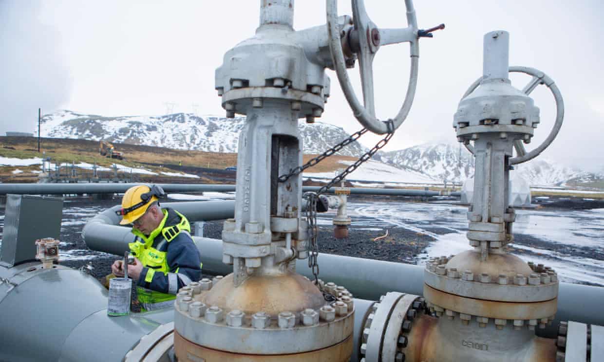
Carbon injection pumps carbon dioxide into wells that lead to igneous and metamorphic rock deposits. There, they can be mineralized by interacting with two types of rock, basalt and ultramafic. Ultramafic rocks have high amounts of iron and magnesium, and are capable of mineralizing CO2 in under two years. Carbon injection was proven effective in Iceland in 2013. The Orca geothermal power plant captured its own carbon dioxide emissions, mixed them with water, and pumped them into the volcanic basalt rock below. The experiment injected 175 tons of CO2 into the ground, and found that 95% of the gas had mineralized into carbonate within two years (Hirji, 2016). The success Orca found proves that the technology is ready, but carbon mineralization still must prove it is safe and cost-effective before policymakers begin to consider implementing it.


Engineer at the Orca power plant in Iceland

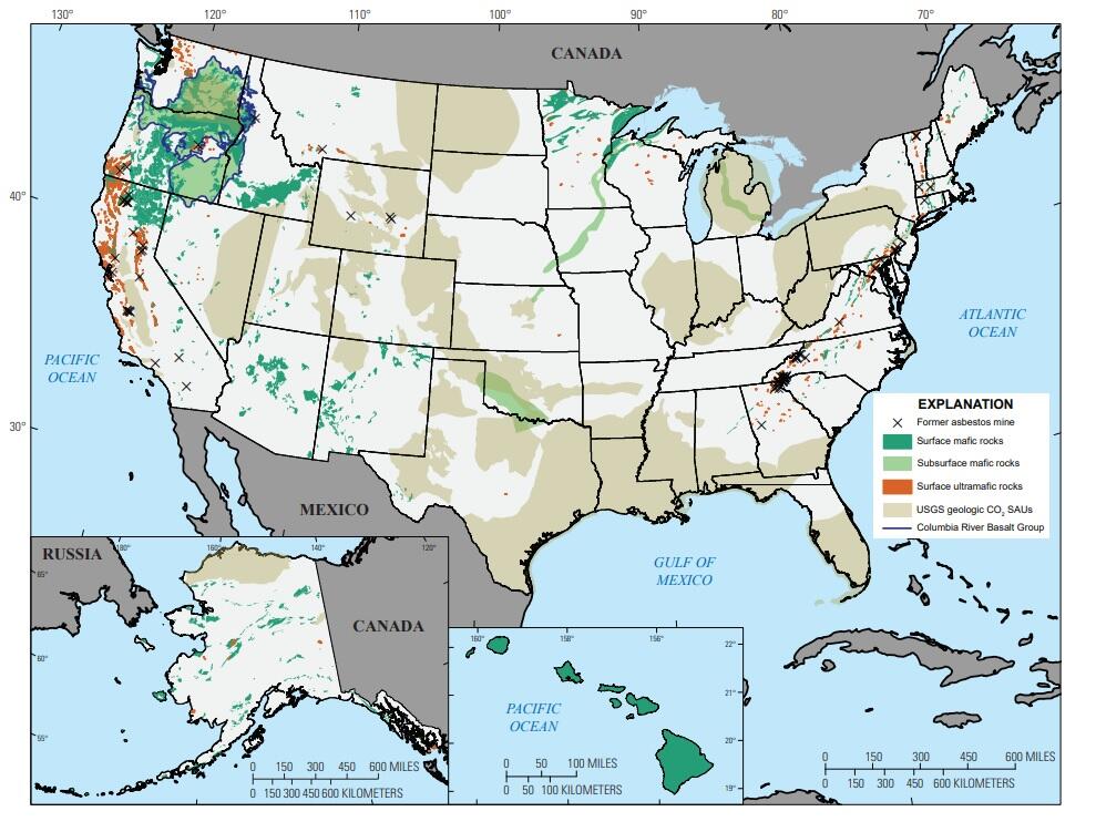
Carbon can also be mineralized by exposure to basalt and ultramafic rocks at the surface. These often come in the form of crushed mining waste. This process is faster than injection, but has a lower overall capability for carbon storage due to the difference in quantity of rock above ground versus underground. This method is being utilized on the rocks of the Oman Gulf, but has been described as only “a drop in the bucket” (Fountain, 2018).


This figure shows areas in the US with the potential for carbon mineralization (USGS, 2022)

Carbon mineralization is currently being utilized in only a few places around the world, but it’s a good step in the right direction. We have a long way to go before it even begins to have a notable effect on CO2 emissions, but the future looks promising for this form of carbon capture. 


Citations:

Fountain, Henry. “How Oman's Rocks Could Help Save the Planet.” The New York Times, The New York Times, 27 Apr. 2018, https://www.nytimes.com/interactive/2018/04/26/climate/oman-rocks.html.

Hirji, Zahra. “Iceland Experiment Successfully Turns CO2 Emissions into Rock.” Inside Climate News, 22 July 2022, https://insideclimatenews.org/news/09062016/iceland-study-ccs-carbon-capture-storage-climate-change-iceland-co2-rock/.

US Geological Survey. “Making Minerals-How Growing Rocks Can Help Reduce Carbon Emissions: U.S. Geological Survey.” Making Minerals-How Growing Rocks Can Help Reduce Carbon Emissions | U.S. Geological Survey, 8 Mar. 2019, https://www.usgs.gov/news/featured-story/making-minerals-how-growing-rocks-can-help-reduce-carbon-emissions#:~:text=Carbon%20mineralization%20is%20the%20process,escape%20back%20to%20the%20atmosphere.